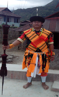
Main Attraction: An Angami youth in traditional attire
The motif represents an Angami youth in traditional dress used generally on ceremonial occasion like Sekrenyi and other traditional festivals
Brief History
Kohima is a hilly district in India's North Eastern State of Nagaland, sharing its borders with Assam State and Dimapur District in the West, Phek District in the East, Manipur State and Peren District in the South and Wokha District in the North. One of the oldest among the eleven districts of the state, Kohima is the first seat of modern administration as the Headquarters of Naga Hills District (then under Assam) with the appointment of G.H. Damant as Political Officer in 1879. When Nagaland became a full fledged state on 1st December, 1963, Kohima was christened as the capital of the state. Since then, parts of Kohima district have been carved out thrice - the first in 1973 when Phek District was created, then in 1998 Dimapur was carved out and declared as a separate district and it was in 2003 for the third time that Kohima district once again gave birth to one of the youngest districts in the state -Peren.
The name, Kohima, was officially given by the British as they could not pronounce the Angami name Kewhima or Kewhira (Tenyidie for "the land where the flower Kewhi grows"). It is called after the wild flowering plant Kewhi, found in the mountains. Earlier, Kohima was also known as Thigoma. Kohima town located in the south of Kohima District is situated on the top of a high ridge and the town serpentines along the top of the mountain ranges as is typical of most Naga settlements.
The name, Kohima, was officially given by the British as they could not pronounce the Angami name Kewhima or Kewhira (Tenyidie for "the land where the flower Kewhi grows"). It is called after the wild flowering plant Kewhi, found in the mountains. Earlier, Kohima was also known as Thigoma. Kohima town located in the south of Kohima District is situated on the top of a high ridge and the town serpentines along the top of the mountain ranges as is typical of most Naga settlements.
Kohima district is predominantly inhabited by people belonging to Angami and Rengma tribes. Like all other Nagas, Angami and Rengma have Mongoloid features. The people are generally healthy and well-built. Angami and Rengma are adept artisans and skilled craftsmen. They weave beautiful designs on their hand-woven mekhelas and shawls.
Major crops of the district include Paddy, Potato, Ginger, Maize, Soyabean, Ricebean, Vegetables and horticultural crops like Banana, Passion fruit, Guava, Temperate fruits. Mount Japfü is the highest mountain peak in the district.
Kohima has a pleasant and moderate climate - not too cold in winters and pleasant summers. December and January are the coldest months when frost occurs and in the higher altitudes, snowfall occurs occasionally. It has an average elevation of 1261 metres (4137 feet).
Kohima Town is one of the three Nagaland towns with Municipal council status along with Dimapur and Mokokchung. The town's population is composed of all the sixteen tribes of Nagaland as well as mainland India residing here.
Kohima has a large cemetery for the Allied war dead maintained by the Commonwealth War Graves Commission. The cemetery lies on the slopes of Garrison Hill, in what was once the Deputy Commissioner's tennis court which was the scene of intense fighting, the Battle of the Tennis Court. The epitaph carved on the memorial of the 2nd British Division in the cemetery has become world-famous as the Kohima poem. The verse is attributed to John Maxwell Edmonds (1875–1958), and is thought to have been inspired by the epitaph written by Simonides to honour the Greek who fell at the Battle of Thermopylae in 480 BC.
“When You Go Home, Tell Them of Us And Say For Your Tomorrow, We Gave Our Today”

No comments:
Post a Comment